


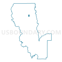
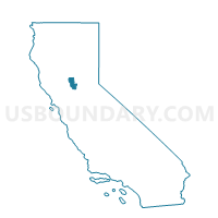
Voting District 10025, Sutter County, California
About
Outline

Summary
| Unique Area Identifier | 545196 |
| Name | Voting District 10025 |
| County | Sutter County |
| State | California |
| Area (square miles) | 0.67 |
| Land Area (square miles) | 0.67 |
| Water Area (square miles) | 0.00 |
| % of Land Area | 100.00 |
| % of Water Area | 0.00 |
| Latitude of the Internal Point | 39.17953780 |
| Longtitude of the Internal Point | -121.71099350 |
Maps

Graphs
Select a template below for downloading or customizing gragh for Voting District 10025, Sutter County, California


Neighbors
Neighoring Voting District (by Name) Neighboring Voting District on the Map
- Voting District 10000, Sutter County, CA
- Voting District 30065, Sutter County, CA
- Voting District 30070, Sutter County, CA
Top 10 Neighboring County Subdivision (by Population) Neighboring County Subdivision on the Map
- Live Oak CCD, Sutter County, CA (10,563)
- Sutter CCD, Sutter County, CA (3,460)
- Yuba City Southwest CCD, Sutter County, CA (2,461)
Top 10 Neighboring Elementary School District (by Population) Neighboring Elementary School District on the Map
Top 10 Neighboring Secondary School District (by Population) Neighboring Secondary School District on the Map
Top 10 Neighboring State Legislative District Lower Chamber (by Population) Neighboring State Legislative District Lower Chamber on the Map
Top 10 Neighboring State Legislative District Upper Chamber (by Population) Neighboring State Legislative District Upper Chamber on the Map
Top 10 Neighboring 111th Congressional District (by Population) Neighboring 111th Congressional District on the Map
Top 10 Neighboring Census Tract (by Population) Neighboring Census Tract on the Map
- Census Tract 507.02, Sutter County, CA (6,205)
- Census Tract 508, Sutter County, CA (3,460)
- Census Tract 510, Sutter County, CA (2,461)